Air-Sea Intereaction and Sea-spray in Typhoons (ASIST)
ASIST is the University of Leeds contribution to Impact of Typhoons on the Ocean in the Pacific (ITOP), a joint US and Taiwanese research programme to improve the effectiveness of forecasting of typhoons in the Pacific Ocean and study the response of the ocean. We are working with Will Drennan, Neil Williams, and Hans Graber at the Rosenstiel School of Marine & Atmospheric Science (RSMAS) at the University of Miami to make direct in situ measurements of air-sea exchange processes under the extreme conditions experienced within typhoons.
The exchange of momentum, heat, moisture, trace gases, and sea spray aerosol all increase with wind speed under typical conditions; however, there is growing evidence that the behaviour of the the exchange processes changes at very high winds (above about 30 m s-1). In these extreme conditions, usually enountered only within severe storms such as hurricanes or typhoons, the drag coefficient stops increasing (possibly even decreases again) and the heat and moisture fluxes differ from the values predicted by bulk flux parameterizations extrapolated from measurements at lower wind speeds. The detailed physics of exchange processes under these conditions are not well understood, and are very difficult to study in situ due to the very hostile environment. It is thought that high volumes of sea spray may modify the exchange processes by exchanging heat and moisture with the air in a layer above the surface; the acceleration of spray droplets by the wind, and their subsequenct fall back into the ocean may also modify the momentum flux. It is important to understand these processes because they are a controlling influence on the development of severe storms. Accurate prediction of the path and intensity of tropical cyclones (typhoons or hurricanes) - of vital importance for the safety of people in the region where the storms make landfall - is dependant on correct representation of the air-sea fluxes with numerical models. Developing improved parameterizations requires direct measurements within the storm systems; this study will make these measurements within typhoons for the first time.
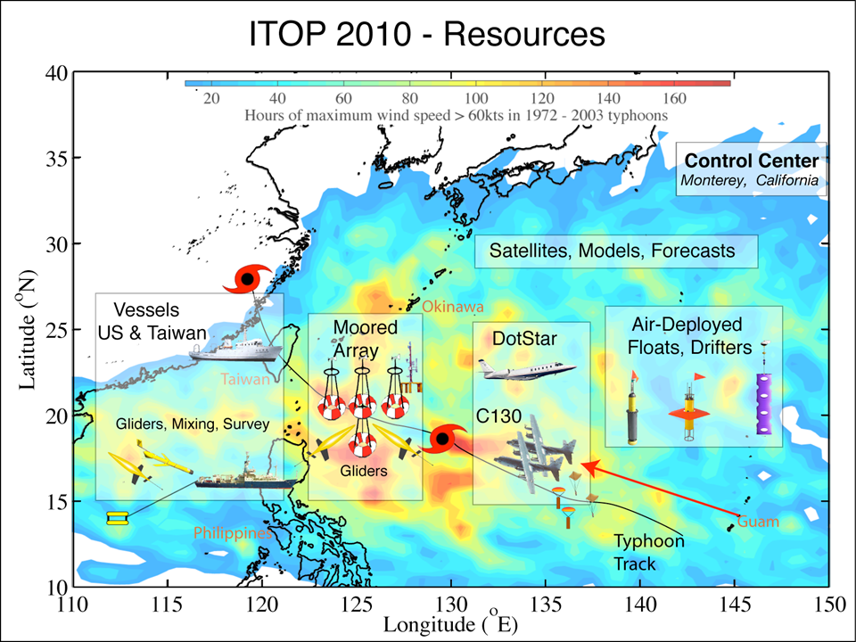
![]() The
full range of measuremement resources being used during ITOP is shown on the
map (click for larger image). They include aircraft, instrumented moorings,
floats and drifters, submarine gliders, and research vessels from both the US
and Taiwan.
The
full range of measuremement resources being used during ITOP is shown on the
map (click for larger image). They include aircraft, instrumented moorings,
floats and drifters, submarine gliders, and research vessels from both the US
and Taiwan.
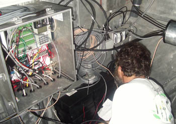
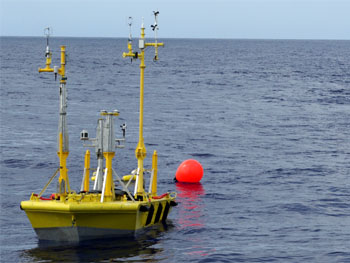
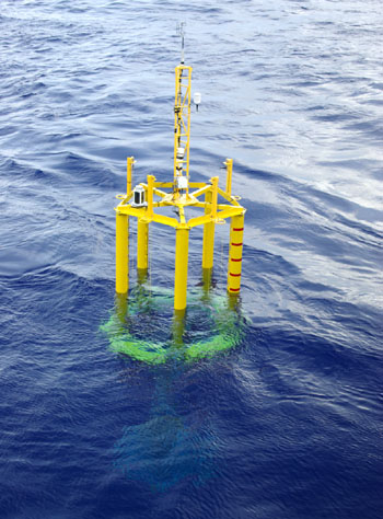
The Leeds group has multiple CLASP instruments integrated into the measurement
systems on the RSMAS Extreme Air-Sea Interaction (EASI) buoys. CLASP measures
the size spectrum of sea spray aerosol, which are thought to have a significant
impact on air-sea fluxes at very high wind speeds. Coupled with other instruments
on EASI, we will be able to measure the exchange of momentum, heat, moisture,
and sea spray aersol between ocean and atmosphere. Two EASI buoys will be deployed
in late July 2010 paired with two Air-Sea Interaction Spar (ASIS) buoys, also
owned by RSMAS, which will make measurements of the surface wave state, and
subsurface measurements of turbulence in the near surface water and the ambient
noise from which information about wave breaking can be derived. The deployments
will be made from the research ship the RV
Roger Revelle. The Revelle belongs to Scripps Institution of Oceanography
at the University of California San Diego. In spite of having worked at Scripps
from 1994-2002 this is the first time I've ever got to work on one of the Scripps
ships.
NEWS - ITOP deployment news feature in Science.
Deployment Cruise Diary:
Realtime information: during the deployment cruise you can see some of what's going on from several realtime webcam feeds, along with a map showing the ship's location, and some other basic status information. One of the webcams is located in the ship's computer lab, where you can see some of the scientists in their natural habitat...sat in front of laptops and drinking coffee! Other cameras show operations on deck.
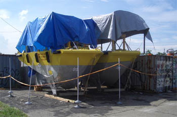
![]() July
25 2010 - Preparations for the deployment of the EASI and ASIS buoys
is almost done. We've been working in a warehouse at pier 2, and the yard outside,
on the waterfront in Kaohsiung Taiwan for about a week. The photo shows the
EASI buoys in the yard - the tarpaulines provide some shade from the sun while
working on them, and protection from the torrential downpour that accompanies
the regular late afternoon thunderstorms. Working inside the buoys is pretty
unpleasant in the tropical heat - much like working in an oven! Below - Will
Drennan and Bjoern Lund working on one of the buoys.
July
25 2010 - Preparations for the deployment of the EASI and ASIS buoys
is almost done. We've been working in a warehouse at pier 2, and the yard outside,
on the waterfront in Kaohsiung Taiwan for about a week. The photo shows the
EASI buoys in the yard - the tarpaulines provide some shade from the sun while
working on them, and protection from the torrential downpour that accompanies
the regular late afternoon thunderstorms. Working inside the buoys is pretty
unpleasant in the tropical heat - much like working in an oven! Below - Will
Drennan and Bjoern Lund working on one of the buoys.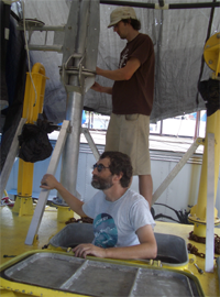
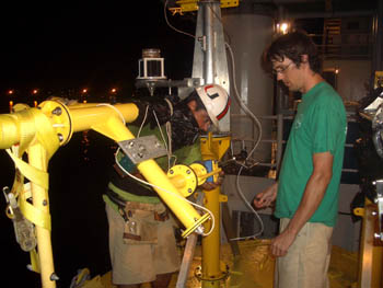
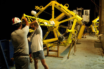
![]() There
are 4 instrumented masts on each buoy, which had to be assembled, and cables
fed down through waterproof seals into the internal hold spaces where the control
and data logging systems should be well protected. Each buoy has two completely
separate sets of instrumentation, power supplies, and data loggers, providing
a high degree of redundancy. The conditions they will experience when hit by
a typhoon truly will be extremem, and we fully expect much of the instrumentation
to be wrecked...worth it as long as we recover the data!
There
are 4 instrumented masts on each buoy, which had to be assembled, and cables
fed down through waterproof seals into the internal hold spaces where the control
and data logging systems should be well protected. Each buoy has two completely
separate sets of instrumentation, power supplies, and data loggers, providing
a high degree of redundancy. The conditions they will experience when hit by
a typhoon truly will be extremem, and we fully expect much of the instrumentation
to be wrecked...worth it as long as we recover the data!
Tomorrow the EASI buoys get put in the water for a ballast test, and then moved
over to the ship. Sailing has been delayed for a couple of days but all being
well we should sail Tuesday afternoon.
July 26, 2010 - Then again, we might be delayed another couple
of days...some issues with internal wiring of the logging systems.
July 27, 2010 - Almost ready - the EASI buoys are almost wired
up, and most of the gear is being shipped over to the ship today. ASIS buoys
are assembled on deck and waiting for their electronics to be installed. Lost
about half of yesterday to torrential rain; it stopped about midday today, then
started up again an hour or two later. 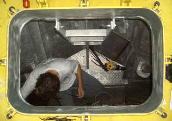
Above - Will Drennan tidying up the wiring in the forward compartment of EASI-1.
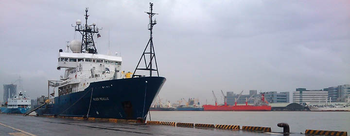 The
R/V Roger Revelle in port in Kaohsiung (in the rain). Port authorities have
had the ship moved back and forth between berths on either side of the port
(which is miles across) 3 times this week. At the moment she's close to the
warehouse where we've been working; we're hoping to finish up and get everything
moved on board before she's moved again.
The
R/V Roger Revelle in port in Kaohsiung (in the rain). Port authorities have
had the ship moved back and forth between berths on either side of the port
(which is miles across) 3 times this week. At the moment she's close to the
warehouse where we've been working; we're hoping to finish up and get everything
moved on board before she's moved again.
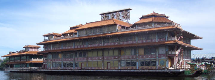 An
old, and now derelict, floating resaurant on the quayside opposite the warehouse.
An
old, and now derelict, floating resaurant on the quayside opposite the warehouse.
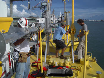
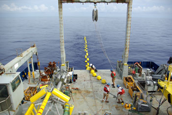
July 29 2010 - The EASI buoys were put in the water yesterday morning in order to adjust the ballast to compensate for the drag of the anchor chain and ensure that they float level. In the end it didn't need much ballast adding - plenty of weight in all the batteries. After that they were moved over the ship on a barge, put on the quayside, and then transferred carefully to the deck. A moorings team from WHOI are now making sure that the plans for moving everything around the - very crowded - deck and into the water actually work.
 |
 |
 |
(above) the transfer of an EASI buoy from the quayside onto the deck. The two ASIS buoys can be seen in the middle image - they were assembled in place on deck. Today the WHOI moorings team will complete their dry-run tests for the deployment. Once they are happy, we can finish the installation of the instrumentation on the buoys. Sailing is now due for Friday morning.
July 31 2010 - At last we're actually underway;
we sailed at 18:00 local time (10:00 UTC) today after a very hectic couple of
days installing all the instruments on the buoys. Yesterday was a very long
day; work started at 8:00, immediately after breakfast, and didn't finish about
23:30. We were disrupted by torrential rain again during the early afternoon,
but rigged up a tarpauline over one of the buoys to all work to continue. Some
of team started again before breakfast this morning, and everything was finally
(almost) ready by 17:00 today.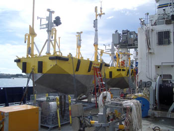
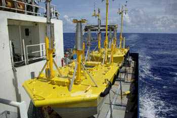
The two EASI buoys are sat on a specially made rail allowing
them to sit one behind the other and slid forward to where they can be lifted
by the ship's crane (above left). (above right) Raphael and Bjoern installing
a sonic anemometer later last night.
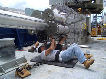
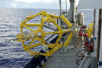
(above left) Mike and Raphael attaching the data logging 'can' to the bottom of one of the ASIS buoys. The other 4 cans contain batteries; (above right) finishing up work on the masts. Each EASI buoy has 4 masts, arranged in two pairs carrying more or less duplicate sets of instrumentation. Each pair is powered from completely independant sets of batteries and is logged by independant data systems. We have CLASP aerosol probes on each system; with the two buoys there are 4 complete systems, providing a high degree of redundency. With luck, one of the systems will survive long enough to obtain a unique set of measurements with a typhoon.
We now have about 36 hours in transit before reaching the site of the first deployment where one EASI and one ASIS will be deployed together. The weather forecast is good, so there should be no problems with the deployment - the deck team have practiced putting all the buoys in the water when they were float tested and ballast adjusted.
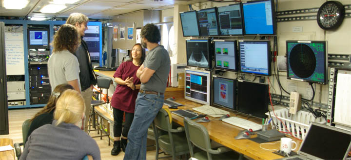
August 1 2010 - 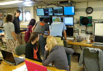
![]() A
beautiful sunny day. Work continues on deck preparing the ASIS buoys, while
for many of us there is relatively little we can do. I've spent most of my time
in the computer lab, taking advantage of the relative peace and quiet to try
and finish up a couple of papers. Light relief has been provided by this afternoon's
safety drill - running through the procedures for abandoning ship. An initial
test release of an XBT (expendable bathythermomograph) was undertaken this morning,
in part to check that the system worked, and in part to check the depth of the
ocean mixed layer - about 35m, more or less what is expected from the regional
climatology. One of the aims of ITOP is to study the deepening of the mixed
layer by turbulent mixing during a typhoon. Following the XBT launch everyone
gathered in the computer lab to examine the data - and take a look at other
data recorded continuously by the permanent ship's instrumentation. This includes
several sonar systems for mapping the sea bed, an acoustic doppler current profiler
to obtain vertical profiles of the ocean currents, and near-surface water temperature
and salinity. All the data, along with navigation data and maps from the bridge
are displayed on the bank of monitors visitble in the photos above and below.
A
beautiful sunny day. Work continues on deck preparing the ASIS buoys, while
for many of us there is relatively little we can do. I've spent most of my time
in the computer lab, taking advantage of the relative peace and quiet to try
and finish up a couple of papers. Light relief has been provided by this afternoon's
safety drill - running through the procedures for abandoning ship. An initial
test release of an XBT (expendable bathythermomograph) was undertaken this morning,
in part to check that the system worked, and in part to check the depth of the
ocean mixed layer - about 35m, more or less what is expected from the regional
climatology. One of the aims of ITOP is to study the deepening of the mixed
layer by turbulent mixing during a typhoon. Following the XBT launch everyone
gathered in the computer lab to examine the data - and take a look at other
data recorded continuously by the permanent ship's instrumentation. This includes
several sonar systems for mapping the sea bed, an acoustic doppler current profiler
to obtain vertical profiles of the ocean currents, and near-surface water temperature
and salinity. All the data, along with navigation data and maps from the bridge
are displayed on the bank of monitors visitble in the photos above and below.
![]()
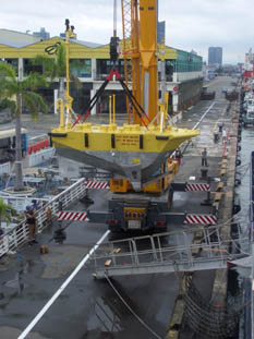
 August
4, 2010 - Today is the big day: the deployment of the first EASI buoy.
Work started about 05:00, and EASI-1 went over the side at about 08:20. The
weather was perfect, low wind, a very calm sea, and overcast - so not too hot
out on deck. The two EASI buoys are stowed on a specially designed rack (above
left) down one side of the ship. She crane is only able to lift their 8-tonne
weight from the nearest slot. After deployment of the first buoy, the second
can be winched back towards the crane where it too can be lifted. The water
depth at the deployment site (approximately 19.5N 127.3E) is about 5500m. To
allow the buoy to move freely the mooring line is 8km long. Immediately below
the buoy is a 60m length of chain, this is attached to about 1.5km of insulated
steel cable, below that is 1km of nylon rope and 4km of polypropylene rope -
the polypropylene is buoyant, and so produces a region of slack in the tether
so that the whole tether should never be put under tension. At the bottom of
the tether the anchor is connected to it by an acoustic release mechanism. When
the buoy is recovered later this year, an acoustic signal will cause the release
to separate the tether from the anchor, and the mooring line and release mechanism
should float to the surface, lifted by a set of plastic-encased glass floats.
The process of paying out the 8km mooring line takes about 8 hours in total.
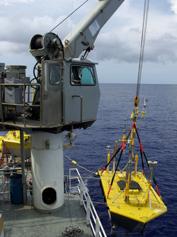
August
4, 2010 - Today is the big day: the deployment of the first EASI buoy.
Work started about 05:00, and EASI-1 went over the side at about 08:20. The
weather was perfect, low wind, a very calm sea, and overcast - so not too hot
out on deck. The two EASI buoys are stowed on a specially designed rack (above
left) down one side of the ship. She crane is only able to lift their 8-tonne
weight from the nearest slot. After deployment of the first buoy, the second
can be winched back towards the crane where it too can be lifted. The water
depth at the deployment site (approximately 19.5N 127.3E) is about 5500m. To
allow the buoy to move freely the mooring line is 8km long. Immediately below
the buoy is a 60m length of chain, this is attached to about 1.5km of insulated
steel cable, below that is 1km of nylon rope and 4km of polypropylene rope -
the polypropylene is buoyant, and so produces a region of slack in the tether
so that the whole tether should never be put under tension. At the bottom of
the tether the anchor is connected to it by an acoustic release mechanism. When
the buoy is recovered later this year, an acoustic signal will cause the release
to separate the tether from the anchor, and the mooring line and release mechanism
should float to the surface, lifted by a set of plastic-encased glass floats.
The process of paying out the 8km mooring line takes about 8 hours in total.
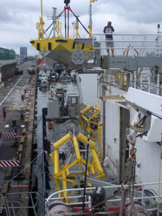
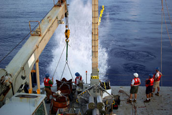
In spite of the perfect weather, the lifting of EASI-1 over the side of the
ship (above right) is quite nerve wracking. The deployment itself was run by
a team of 3 from Woods Hole Oceanographic Institution (WHOI)- they are very
highly experienced, having done more mooring deployments than probably anyone
else in the world - but this is the largest mooring they have ever deployed.
If anything goes even slightly wrong, it would be easy for the buoy to swing
into the ship and damage one of the 4 instrumented masts, trashing some of the
instruments before we even start. In the end everything went very smoothly,
and EASI-1 was in the water about 08:20 local (00:20 UTC). The buoy was then
moved to back to just off the fantail and the bottom end of the chain attached
to the steel mooring cable. At this point the buoy sits with its bow high in
the water - it is ballasted to sit properly when it has the full weight of the
mooring line attached. As the cable is payed out, water temperature loggers
are attached at intervals down to about 200m - these will provide a record of
changes in the ocean mixed layer depth over time.
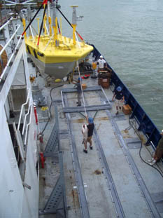
![]() After
dropping the anchor for the buoy (above right), it takes 45 minutes for it to
reach the bottom. And then, on to the next job - finishing the preparation of
the first ASIS buoy for deployment at first light (right).
After
dropping the anchor for the buoy (above right), it takes 45 minutes for it to
reach the bottom. And then, on to the next job - finishing the preparation of
the first ASIS buoy for deployment at first light (right).
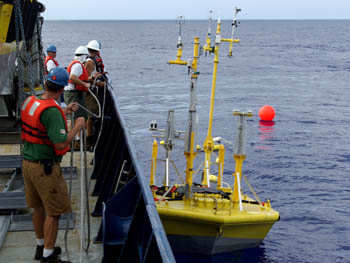
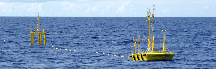
August 5, 2010 - Another 5am start to the day. The first ASIS
buoy was deployed at 06:20 local (22:20 UTC) this morning. Seas are still very
calm, and it went in the water very smoothly and was then towed gently over
to EASI-1 and attached to the tether. ASIS should float about 80m or so down
wind of EASI. ASIS is very stable in the water, riding the swell which smaller
wind-waves pass straight through it. An array of wave wires records the wave
heights as they pass through to an accuracy of about 1cm. It is possible to
get rather higher resolution (~1mm), but because of the extreme conditions within
a typhoon, thicker, stronger, but less sensitive, wave wires have been fitted
for this deployment. One finer wire is also fitted;it probably won't survive
until the recovery, but the data up until the point that it breaks will be used
for intercomparison and calibration of the heavier wires.
![]()
 While
ASIS is a very stable platform in moderate sea states, and thus ideal for making
turbulent flux measurments, it may get overtopped by large breaking waves in
a typhoon. The EASI buoy rides large waves much better, but also has a much
greater degree of motion, making motion-correction of the turbulence data more
difficult.
While
ASIS is a very stable platform in moderate sea states, and thus ideal for making
turbulent flux measurments, it may get overtopped by large breaking waves in
a typhoon. The EASI buoy rides large waves much better, but also has a much
greater degree of motion, making motion-correction of the turbulence data more
difficult.
The conditions during the deployment are at one extreme of the range of sea
states - almost dead calm, winds of 3 or 4 m s-1 with wave heights of much less
than 1 m. The conditions in which we want measurements are at the other extreme:
winds in excess of 30 m s-1 and wave heights of 10-20 m.
Now that the first pair of buoys is deployed, a short CTD sounding will be made
to determine the intitial structure of the upper 1500 m or so of the ocean,
and then we move back north to deploy the second pair of buoys.
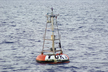
On the way north we detoured to check on a Taiwanese ATLAS
mooring which had stopped reporting data about a month ago, just to make sure
it was really still there. Any long-term mooring tends to accumulate its own
community of wildlife. At the top of the food chain in these communities are
fish - so as soon as the mooring was found, out came the fishing rods.
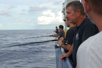
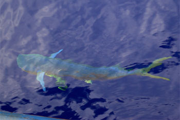
(above left) the crew fishing from the aft deck, and (above
right) a Mahi. In the end about half a dozen Mahi were caught; they made a delicious
dinner the following evening.
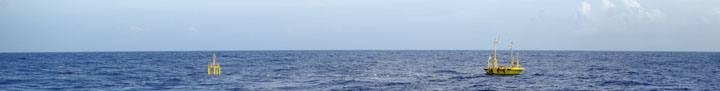
August 7, 2010 - The second EASI buoy got deployed yesterday before breakfast. Everything went very smoothly in spite of a heavier swell than on the first deployment. The anchor for it was dropped about 15:00 local time. The second ASIS buoy was then moved from near the centre of the aft deck to the starboard side to provide enough space to put the mast on it. The evening was then spent installing the remaining instruments, finishing up with a troublesome sonic anemometer at about 23:00. It had been intended to deploy ASIS first thing this morning, but the wind and waves have increased over night - the significant wave height is now about 2.6 m, too high to safely put ASIS over the side. So, deployment is postponed and we are steaming south to check on the first deployment and on a Taiwanese buoy further south, and deploy a buoy for someone else before heading back to the northern deployment site. If the weather improves, ASIS will get deployed, if not....we're out of ship time and will have to return to Kaohsiung.
August 8, 2010 - Yesterday's weather developed a bit more and we are now sat more or less in the middle of a tropical cyclone. Waves got up to a little over 3m, so not too bad (during my first cruise we got single waves up to 17 m!). The ride was still a little bumpy while heading south last night - especially for those of us with cabins in the bow where the ship motion is greater than amidships. The ATLAS mooring we were to check up on was located around 01:30 this morning, and we held station there unti about 05:00 - which means using the bow thrusters, which are very noisy if you happen to have a cabin next to them! We are now heading north again, with the waves, so the ride is smoother. The forecast is for the weather to calm down again by the 10th, so we hope to deploy ASIS that morning.
August 9, 2010 - Our tropical storm now merits a name: Dianmu (satellite imagery, NASA storm history). The wind has dropped since yesterday, but we still have 4m seas, with waves coming from both the south and west. Between the rocking and rolling of the ship, and the noise of the bow thrusters not much sleep was got last night. The storm did put on a pretty good light show though - I spent an hour or so late last night on the bridge watching the lighning: a constant flash or two a minute for hours on end (having studied thunderstorms for my PhD I still have a soft spot for a good lightning show). At the moment we're just holding position, hoping things calm down enough to deploy the final buoy before we have to return to port. While there's not much to do now related to this project, I have managed to finish up a long-neglected paper;that's two papers finished on this cruise - I should come to sea more often!
August 10, 2010 - ASIS-2 finally got deployed this morning. All the buoys are now in the water and working, and there's nothing to do but hope eveerything keeps working until the recovery in early November, or at least until they've been through a typhoon.
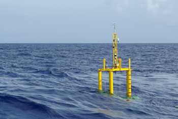
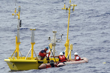
(above left) ASIS-2 in the water at last. (above right) recovering the lifting
straps from EASI-2.
 |
 |