Carpathian Basins Project: 2005-2008
The UK Natural Environment Research Council (NERC)
announced on June 22, 2005 that it would fund a major research
project whose theme is to understand the role of extension and
convergence in the Carpathian Pannonian system of Central Europe.
Principal Investigators on this project are Prof Greg Houseman and Dr
Graham Stuart of the University of Leeds. The project is proceeding
in close cooperation with Endre Hegedűs, Research Director of the
Eötvös Loránd Geophysical Institute of Budapest,
Prof. Ewald Brückl of the Vienna University of Technology and
Slavica Radovanovic, the director of the Seismological Survey of
Serbia. Major equipment for the project is provided by SEIS-UK,
a part of the NERC Geophysical Equipment Facility. Support from the
Royal Society has enabled further development of the project in
conjunction with the Geophysics group of Prof Frank Horváth at
Eötvös Loránd University in Budapest.
Project Summary
The Pannonian Basin was formed as a result of
extension of the crust and lithosphere between about 20 and 15
million years ago. To understand why this occurred, and what is the
present day structure in the outer few hundred km of the Earth
beneath this basin, we plan to: (A) run experiments on computer
models that simulate the stress and strain-rate fields and
deformation processes on geological timescales, and (B) make
seismological measurements of the lithosphere and upper mantle in its
present state. We will integrate the results of numerical modelling
using a new 3D computer model of gravitational instability in the
Earth's crust and lithosphere, and new seismological measurements
from a temporary array deployed in Hungary and Austria, in order to
develop new and quantitative dynamical models of the extensional
process.
Seismic Array Deployment
As part of this study, two new temporary seismic
arrays are being deployed in Austria and Hungary during the period
2005-2007.
Regional Broadband (RBB) Array
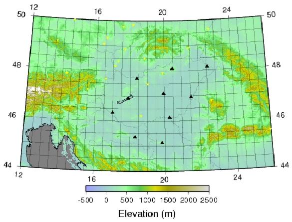 Alongside
existing permanent stations run by national authorities (Yellow
triangles on the map), a 10-station Regional Broadband (CBP-RBB)
Array using Guralp CMG3T sensors (broadband to 100 sec) was deployed
starting in September 2005 (Black triangles) with 8 stations across
Hungary, one in Croatia and one in Serbia (in cooperation with the
Seismological Survey of Serbia). We plan for continuous recording for
approximately 2 years at 100 samples per second. This array
will provide broadband data for determination of structure of the
crust and lithosphere by measuring surface wave propagation across
the basin, receiver functions, and measurement of anisotropy from
shear wave splitting.
Alongside
existing permanent stations run by national authorities (Yellow
triangles on the map), a 10-station Regional Broadband (CBP-RBB)
Array using Guralp CMG3T sensors (broadband to 100 sec) was deployed
starting in September 2005 (Black triangles) with 8 stations across
Hungary, one in Croatia and one in Serbia (in cooperation with the
Seismological Survey of Serbia). We plan for continuous recording for
approximately 2 years at 100 samples per second. This array
will provide broadband data for determination of structure of the
crust and lithosphere by measuring surface wave propagation across
the basin, receiver functions, and measurement of anisotropy from
shear wave splitting.
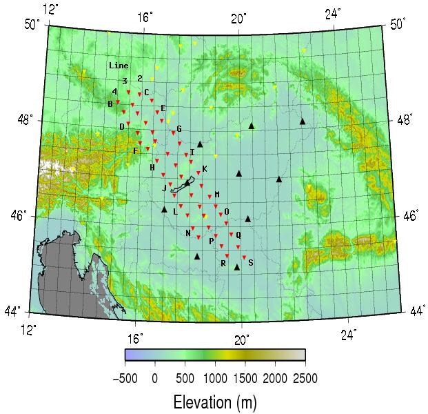 High-resolution
Seismic Tomography (HST) Array
High-resolution
Seismic Tomography (HST) Array
Starting in April 2006 we have deployed an array for
high-resolution seismic tomography (CBP-HST, red symbols on map) for
approximately one year. This array of 46 stations using Guralp
6TD triaxial sensors (broadband to 30 seconds) provided by SEIS-UK
will provide data to enable a high-resolution seismic tomography
investigation of the Vienna and western Pannonian Basins
approximately across-strike of major structural features like the
Peri-Adriatic line and the mid-Hungarian line. The map shows 15
stations deployed in Austria (in April), 25 in Hungary (in May), and
6 stations in Serbia (in July).
Photographs of the Austrian HST stations can be
seen at HSTA.
Further photographs of equipment and deployment methods used in
Austria are provided here.
Photographs of the Hungarian HST stations can be seen at HSTH.
Photographs of the Serbian HST stations can be found at HSTS.
Numerical Modelling of Lithospheric Deformation
A new parallelised 3D Finite Deformation program has
been developed at Leeds during 2004-2005 by Lykke Gemmer, Greg
Houseman and Stuart Borthwick, with the support of the Leverhulme
Foundation. This program (called oregano) is now being
used in a program of numerical experiments testing the hypothesis
that the development of the Carpathian Basins and surrounding
mountain chains has proceeded as a direct consequence of a
gravitational instability of the continental mantle lithosphere
beneath the Basin.
Research Personnel
Following Dr Gemmer's departure to join Statoil in
Norway, Dr Piroska Lorinczi has been appointed as a Research Fellow
to work on the geodynamical modelling part of the project. Array
operations in Austria are managed by Mr Helmut Hausmann and in
Hungary by Mr Attila Kovacs. Mr Ben Dando will commence his PhD
studies at Leeds in October 2006, working on the seismological part
of the project.
Project Aims
to develop new time-dependent 3D numerical models of the large-scale
strain history of the Pannonian Basin region using a dynamically
self-consistent finite element model that solves the basic equations
of conservation of mass and momentum in a spatially varying viscous
creeping flow, driven by boundary and internal buoyancy forces.
to provide controls on these models by improving the resolution of
seismic images of the lithosphere and upper mantle, using data
obtained from the two seismic arrays described above.
Seismic
tomographic images obtained using data from existing regional arrays
shows that the upper mantle of the Pannonian Basin has undergone a
major disturbance that is either associated with subduction of
oceanic lithosphere or gravitational instability of the continental
lithosphere. The lithosphere is anomalously hot and thin and the
transition zone contains anomalously cold (seismically fast)
material, which observations together imply a general overturn of the
upper mantle beneath this region.
Seismicity
maps show current deep (to about 180 km) seismic activity beneath the
Vrancea Zone of the Romanian Carpathians which, in conjunction with
the tomographic images, may be interpreted as continuing downwelling
of continental mantle lithosphere.
Studies of
the thermal and subsidence history of the Pannonian Basin have shown
that the continental lithosphere in this region has undergone a
period of rapid extension in the Miocene that has resulted in the
thinning and heating of the crust and lithosphere. Crustal and
lithospheric extension factors are variable but, in general, the
extension factors of the lithosphere appear to be greater than those
of the crust by a factor of 2 or 3.
The
Carpathian Mountain system encloses several inter-related basins of
which the Pannonian is the largest. The lithosphere in the Pannonian
may be separated into two domains by major ENE trending structural
lineations that include the Balaton line and the mid-Hungarian line.
To the NW the Vienna Basin is smaller, but clearly related to the
development of the Pannonian system. It remains unclear how these
structural elements have interacted during the basin-forming
extensional event.
Seismic
analysis methods based on data from the new CBP arrays will include
receiver functions, surface wave analysis, shear wave splitting and
tomography using body waves and surface waves. All of these methods
will be used in conjunction with the 3D geodynamical modelling, to
help understand how these structural elements have interacted during
and since the Miocene basin forming event.